GPS coordinate
GPS coordinates are used for locating and uniquely determining the position of goods, means of transport and living beings. GPS coordinates are specified in numeric or alphanumeric form and indicate the exact geographical position on the earth.
Navigation devices represent the determined geographic coordinates as latitude and longitude. Latitudes represent the distance from the equator given in degrees. This forms the zero degree value. The north and south poles form the 90° value in north (N) and south (S) direction, respectively. The reference of the longitudes forms the zero meridian and the coordinates refer to east (E) or west (W) direction.
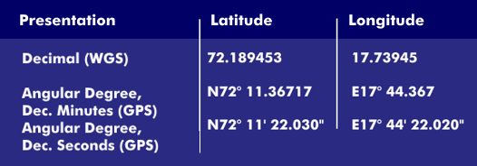
GPS systems display the earth coordinates in latitude and longitude. The representation itself can be decimal according to the World Geodetic System (WGS), in degrees and decimal minutes or in degrees, minutes and seconds. Coordinates that refer to the southern hemisphere and/or lie west of the prime meridian are indicated in decimal notation with a minus sign.